Preamble
The information on this page hopefully will describe the layout of the Parish and Suburban Lots and the ongoing changes that were made, it also hopes to explain the different types of land acquistions that were made available to potential landowners or grantee's of lands.
Originally the names of purchased land were called either "Portions" or "Allotments" as noted on the various Land Purchase documents, but in time this nomenclature was replaced with the simple term "Lot", I have used Lot throughout this web site.
Ownership of the various Lots
The focus of ownership of the Lots within and around the township has been initially on the first Grant and following Certificate of Title. On the rare occasion is the current owner included in the lists.
No Mortgages or Caveats have been included as these are or can be of a personal nature and do not provide any pertinent information on the Lots.
Surveying Instruments
Surveying the Lots entailed using either of two types of instruments:
These were supported by the Gunters Chain for measuring the distances. At every corner of a Lot a stake was driven and the corners were lockspit.
Types of Land Purchases
Terminology
Parish and Suburban Lot Notes
Originally the names of purchased land were called either "Portions" or "Allotments" as noted on the various Land Purchase documents, but in time this nomenclature was replaced with the simple term "Lot", I have used Lot throughout this web site.
There are four area's which fall within the scope of this research:
1. That part of the Parish of Cummings (PoCu), DP756877 located in the north west of the Tambaroura,
2. That part of the Parish of Carroll (PoCa), DP756873 located in the east of the Tambaroura,
3. Parish of Tambaroora (PoT), DP756905 in the centre which covers the majority of the area, and
4. The Township (ToT), DP758950.
There are two types of lots, the Parish Lots outside the town boundary and the Suburban Lots located within the town boundary.
Lot numbers within the parishes were accounted for using a numbering system or in some cases at the time of the original Lot sale an alphabetical reference was also used, hence there could be three Lot 10's, one in each parish.
There have also been changes made to the parish boundaries in the past. The most notable change was made between the Parish of Carroll and the Parish of Tambaroora within the township of Tambaroora Proper.
Early survey plans not only show the Lot number but also an alphabetical listing which appeared on some of the Auction Sale notices in the Government Gazettes.
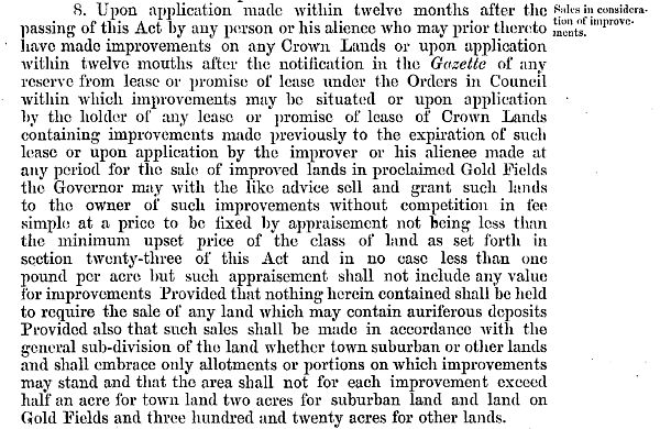
The time between an application for an "Improvement Purchase" and the actual purchase could be up to a few years before there was a settlement. Although not researched a possible reason could be the backlog of purchases being made throughout the Colony at the time and the duration taken in communicating with the appropriate authorities.
In some cases where "Improvement Purchases" were made, the purchaser did not follow up on the purchase and failed to pay the required amount for the land within the required period, in which case the land was forfeited from the purchaser. This is reflected on some Survey Plans and Charting Maps where the persons name has been entered on the map but they never actually completed the transaction and purchased the land.